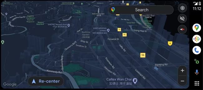
Google Maps has long offered a 3D view that displays buildings in certain regions, enhancing the map’s visual representation and aiding in orientation. Now, that very same perspective has been unlocked for navigation purposes. However, there’s a catch to the current availability.
Please follow us on Twitter and Facebook
Introduction of 3D Navigation in Google Maps
Google Maps consistently integrates practical features into its interface. Yet, when it comes to altering the visual aspect, Google proceeds cautiously, taking gradual steps forward. This cautious approach is evident in the current rollout of 3D navigation. During navigation, Google Maps is now directly presenting some early users on Android and iPhone devices with a 3D view.Here’s what it looks like:

User Experience on Reddit
A Reddit user detailed their experience, noticing a navigation view change a week ago, with buildings now depicted. While streets, names, and Points of Interest (POIs) such as gas stations remain focal points, the buildings are distinctly outlined. This enhancement allows for improved identification of addresses or stores, as users no longer solely rely on street names and descriptions but can visually locate the actual buildings.
Read Also: Google Drive: How To Recover Your Lost Data
Limited Availability of 3D Navigation in Google Maps
Presently, users cannot manually activate the 3D navigation feature in Google Maps. Google determines who gains access to this new view. These early stages likely constitute a trial phase aimed at gathering user feedback. The new view supports all systems, including smartphones, Android Auto, and Apple CarPlay. The duration of this trial for selected users remains undisclosed. Rest assured, once Google officially announces the feature’s release, we’ll promptly provide updates.
Read Also:
Google Messages Launches Ultra HDR Photo Sharing For RCS Chats
Google Unveils Gemini: The Cutting-Edge AI Model Outshining GPT-4


